
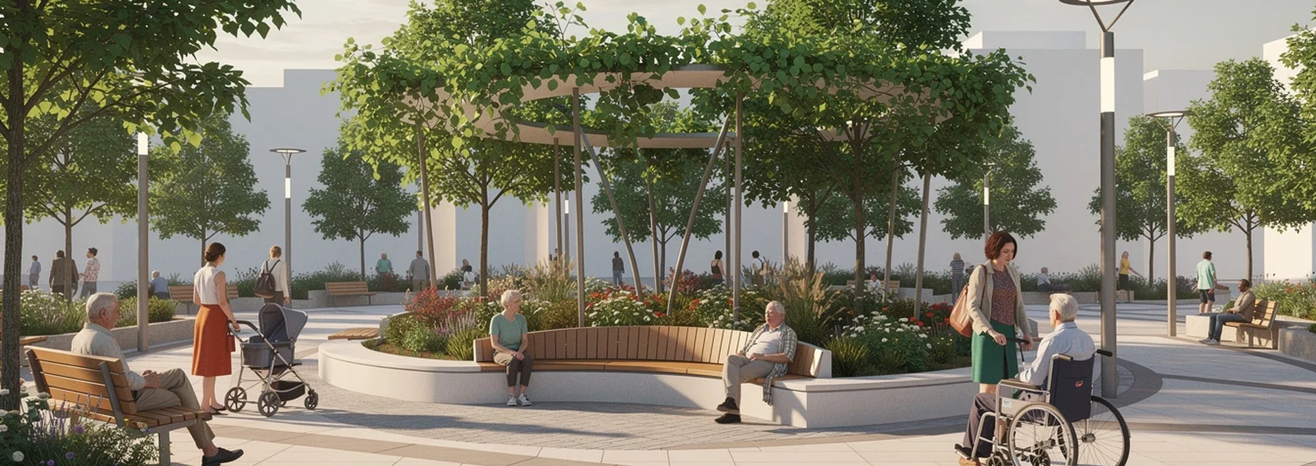
Public spaces succeed or fail on details that most people never consciously notice: where a bench sits, how a path curves, whether a light casts even glow or harsh glare. Yet these details determine who uses a park, street or plaza, and who avoids it. Decades of research into human behaviour, environmental psychology and urban design have produced a robust body of evidence about what makes public space work. This article draws on that evidence to examine the core principles behind comfortable, safe and well-used places, from foundational design theory and crime prevention strategies through to material science, wayfinding and real-world regeneration projects. The aim is practical: to show how thoughtful, evidence-based design turns underused or uncomfortable spaces into places where people genuinely want to spend time.
Principles of Human-Centred design in public realm planning
Human-centred design starts from a simple premise: public space should be shaped around how people actually behave, not how planners assume they behave. This means observing real use patterns, testing assumptions, and designing for the full range of bodies, ages and needs that make up a community.
Jan gehl’s “life between buildings” methodology
Danish architect Jan Gehl argued that the quality of a city should be measured by the life that happens between its buildings, not by the buildings themselves. His methodology prioritises pedestrian experience at eye level and human walking speed, examining how street width, building frontage, and the rhythm of doors and windows encourage or discourage lingering. Gehl’s approach distinguishes between necessary activities, which happen regardless of environmental quality, and optional or social activities, which only flourish when a space is genuinely inviting. This distinction remains central to contemporary placemaking: a street can move people efficiently while still failing entirely as a place to pause, meet, or rest.
William H. whyte’s behavioural mapping techniques
William H. Whyte’s pioneering studies of urban plazas relied on direct, patient observation rather than assumption. Using time-lapse film and systematic notes, Whyte tracked exactly where people chose to sit, stand and gather, revealing that factors such as moveable chairs, proximity to street activity, and the availability of sittable edges predicted success far more reliably than a plaza’s size or landscaping budget. Behavioural mapping remains a core tool in public realm planning today, giving designers empirical evidence of actual use rather than relying on intuition alone.
Universal design and inclusive accessibility standards
Universal design aims to create environments usable by the widest possible range of people, regardless of age, size or ability, without the need for adaptation. In practice, this goes beyond simple compliance with minimum accessibility requirements. Genuinely inclusive design considers wheelchair users, people with prams, those with visual or hearing impairments, and neurodivergent visitors alike. Barriers such as poorly placed ramps, obstructed pavements or malfunctioning lifts send a clear, unintended message that some users are less welcome than others. Meaningful inclusion also means looking beyond physical mobility: sensory needs, cognitive differences and cultural familiarity all shape whether someone feels able to use a space with dignity and confidence.
Prospect-refuge theory in spatial layout
Prospect-refuge theory holds that people feel most comfortable in spaces that allow them to see out (prospect) while also feeling sheltered or protected (refuge). This principle explains why cafe seating against a wall, benches beneath a tree canopy, or alcoves overlooking an open lawn tend to be favoured spots. Applied to public space design, prospect-refuge thinking helps planners balance open sightlines for safety with the more intimate, enclosed settings that people seek out for rest, conversation or people-watching.
Crime prevention through environmental design (CPTED)
Crime Prevention Through Environmental Design, or CPTED, is a planning framework that uses physical design to discourage criminal behaviour and increase both real and perceived safety. Rather than relying solely on policing, CPTED works by making spaces more visible, better used and clearly cared for, so that legitimate activity naturally displaces opportunities for crime.
Natural surveillance and sightline optimisation
Natural surveillance relies on the presence of people going about ordinary activity to passively monitor public space. As urbanist Jane Jacobs observed,
there must be eyes upon the street, eyes belonging to those we might call the natural proprietors of the street
. Landscape architects support this by designing rounded corners rather than blind ones, carefully managing vegetation height so it does not obscure views, and using even, well-distributed lighting rather than isolated bright spots that create pockets of darkness by contrast. Surveys have found that a large majority of women feel unsafe walking alone in parks after dark, compared with a small minority in daylight, underlining how visibility directly shapes who feels able to use a space and when.
Territorial reinforcement through landscape boundaries
Territorial reinforcement uses landscaping, paving changes, low walls and planting to signal ownership and transition between public, semi-public and private zones without resorting to hostile barriers. Clearly defined boundaries help users understand who a space is for and how it should be used, while also making unauthorised or antisocial behaviour more conspicuous. Breaking a large open space into smaller, semi-enclosed areas can support a broader mix of activities and user groups, preventing any single space from being dominated by one group at the expense of others.
Access control and defensible space strategies
Defensible space strategies manage how people enter, move through and exit a space, ensuring routes are direct, well-lit and free from obstruction. Multiple, clearly visible entrances reduce the sense of entrapment that a single hidden access point can create, while a legible hierarchy of paths, including circular routes, alternative options and clear sightlines to escape routes, gives users a genuine sense of control over their movement. This is particularly important for people who routinely calculate safety risks when deciding whether to enter or cross a space.
Maintenance protocols and the broken windows theory
The broken windows theory suggests that visible signs of neglect, such as litter, graffiti or damaged furniture, signal that a space is unmonitored and can encourage further disorder. Robust, well-maintained infrastructure, from vandal-resistant materials to reliable bin provision, communicates that a space is cared for and watched. Consistent maintenance is not a cosmetic afterthought; it is a functional part of a safety strategy, reinforcing positive perceptions and encouraging continued legitimate use.
Thermal comfort and microclimate management
As extreme weather events become more frequent, thermal comfort has moved from a secondary consideration to a central design requirement. Public spaces that fail to manage heat, wind or water become unusable at precisely the moments communities need them most.
Urban heat island mitigation via tree canopy coverage
Trees are among the most effective and cost-efficient tools for reducing urban heat. Canopy cover lowers surface and air temperatures through shading and evapotranspiration, while also improving walking conditions and air quality. Beyond heat mitigation, trees and raised footpaths help cities cope better with flooding, making canopy coverage a dual-purpose intervention that supports both comfort and climate resilience.
Wind tunnel effects in High-Rise plaza design
Tall buildings can funnel and accelerate wind at ground level, creating uncomfortable or even hazardous conditions in surrounding plazas. Designers mitigate this through building massing, podium design, and strategically placed landscaping or screening that breaks up airflow before it reaches pedestrian areas. Left unaddressed, wind tunnel effects can render an otherwise well-designed plaza unusable for large parts of the year.
Shading structures and pergola orientation
Purpose-built shading, from pergolas to canopies, extends the usable hours and seasons of a public space. Orientation matters: structures must be positioned according to the sun’s path to provide shade when and where it is most needed, such as over seating areas or children’s play zones. Some cities have gone further, repurposing infrastructure such as underpasses into shaded parks, adding basketball courts, swings and table tennis facilities beneath existing overhead structures.
Permeable paving materials for surface temperature reduction
Permeable paving reduces surface temperatures compared with conventional impermeable materials, while also allowing water to drain through rather than pool or run off into drainage systems. This dual benefit, cooling and flood mitigation, makes permeable surfaces a practical choice for paths, plazas and car parks, particularly in areas prone to heavy rainfall or heat stress.
Material selection and durability engineering
The materials chosen for a public space affect safety, longevity and how a place is perceived from its very first use to years of daily wear.
Slip-resistant surfacing standards (BS 7976 pendulum testing)
Slip resistance is tested using pendulum methods such as those set out in BS 7976, which measure the friction between a surface and a simulated foot or shoe under wet and dry conditions. This testing informs material choice for paths, ramps and plazas, particularly in areas exposed to rain, ice or heavy foot traffic, helping to prevent falls among users of all ages and abilities.
Anti-vandalism coatings for street furniture
Street furniture in public spaces is subject to constant use and occasional misuse. Anti-graffiti coatings, robust powder-coated finishes and vandal-resistant fixings extend the lifespan of benches, bins and signage while reducing the visible signs of neglect that can undermine perceptions of safety. Specifying furniture that is robust to graffiti and vandalism is a practical way of sustaining positive first impressions over time.
Corten steel and weathering applications in landscape architecture
Corten steel, which develops a stable, rust-like patina as it weathers, is widely used in landscape architecture for its low maintenance requirements and distinctive aesthetic. Its warm, evolving surface can help integrate contemporary structures into natural or industrial settings, offering durability without the ongoing cost of painted or coated alternatives.
Wayfinding systems and legible urban navigation
Legibility, the ease with which people can understand and navigate a space, has a direct bearing on comfort and confidence, particularly for first-time visitors or those with additional access needs.
Kevin lynch’s five elements of the city
Urban theorist Kevin Lynch identified five elements that shape how people mentally map a city: paths, edges, districts, nodes and landmarks. Clear paths and recognisable landmarks reduce disorientation, while well-defined edges and districts help people build a coherent understanding of how spaces connect. Applied to public realm design, Lynch’s framework underpins wayfinding strategies that make parks, streets and plazas intuitive to navigate, even for those unfamiliar with the area.
Tactile paving for visually impaired pedestrians
Tactile paving uses raised surface patterns to alert visually impaired pedestrians to changes in the environment, such as approaching kerbs, crossings or platform edges. Consistent, standardised use of tactile paving across a public realm is essential; inconsistent application can create confusion or false confidence, undermining the very safety benefit it is designed to provide.
Digital signage integration with GPS-Based applications
Increasingly, physical wayfinding is complemented by digital tools, with signage integrated alongside GPS-based applications that offer real-time navigation, accessibility information and points of interest. This layered approach supports a wider range of users, including visitors unfamiliar with an area and people who rely on digital aids to navigate confidently and independently.
Case studies in successful public space regeneration
Real-world projects demonstrate how these principles combine in practice, transforming underused, neglected or purely functional spaces into places people actively choose to visit.
The high line, new york: Post-Industrial adaptive reuse
The High Line transformed a disused elevated freight rail line into a linear park, demonstrating how industrial infrastructure can be adaptively reused rather than demolished. The project combined careful planting design with framed views of the surrounding city, creating a distinctive elevated route that has become a model internationally for turning obsolete infrastructure into valued public space.
Superkilen park, copenhagen: Community-Driven multicultural design
Superkilen Park was designed through extensive engagement with the surrounding multicultural neighbourhood, incorporating objects and design references contributed by residents from dozens of different national backgrounds. The result is a park that reflects the identities of the community it serves, illustrating how participatory design processes can produce genuinely distinctive and locally meaningful public space rather than generic landscaping.
Exhibition road, london: shared surface woonerf principles
Exhibition Road applies “woonerf” or shared surface principles, removing traditional kerb separation between vehicles and pedestrians to create a single, level surface governed by informal social negotiation rather than strict traffic segregation. This approach slows vehicle speeds and prioritises pedestrian movement, reflecting a broader shift in urban planning away from car-centric design towards streets that function as genuinely shared public space.